GSIPL has well developed High Resolution (HR) 2D seismic data acquisition tool in response to needs for high resolution imaging which have arisen during detailed studies of the margins (complex sedimentary processes, outflows of fluids and gas hydrates and associated ecosystems).
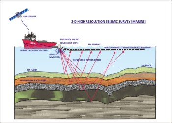
Acquisition System This system includes seismic streamers, seismic acquisition electronics, an engineering sensor kit (positioning) and on-board quality control processing tools.
High-Resolution 2D and 3D Marine Seismic Reflection Profiling
GSIPL is in use of marine seismic reflection technology to advance geoscience knowledge through research, identify and mitigate geological hazards, locate and develop energy and mineral resources, and provide marine science and engineering expertise for the development and growth of national and global societies. Although 3D seismic reflection profiling is one of the most advanced technologies used in marine geoscience, there remain significant requirements for 2D seismic profiling and use of other advanced technologies in academic marine geosciences. In particular, high-resolution multi-channel seismic (MCS) profiling, both 2D and 3D, is needed for a wide range of investigations for inshore, coastal, and deep ocean environments. For example, geological hazards studies must locate and map active faults, landslides and other slope instability, petroleum, natural gas, and hydrate/clathrate accumulations and seeps, hydrothermal and volcanic systems with high-resolution to understand processes involved in their development and to develop strategies for hazard mitigation. Likewise, high-resolution seismic stratigraphy is needed for fine-scale investigation of sedimentary processes and climate change. In coastal areas, society needs better understanding of the interaction between fresh water aquifers and seawater intrusion to protect vital groundwater resources–high-resolution seismic techniques can provide important data to examine these systems. |